Paved roads in Montenegro
Attention!
In Montenegro, several road sections have time-based traffic restrictions in 2026.
In the morning, you may be allowed to drive in one direction, and in the evening — in the opposite direction.
Google tries to build routes based on these rules. As a result, at different times of the day, it may give completely different route options.
My routes are affected by this as well. If you open them at different times, instead of the usual average of around 5 hours of riding per day, you may see 7–8 hours.
The best time to check and plan the routes is after 19:00, when no restrictions are active. This way, you can realistically estimate the time needed for the ride.
WARNING: the road from Đurđevića Tara Bridge to Mojkovac is OPEN after repair work following several rockslides in the season 2025-26. At this moment, it is possible to get through. Google.Maps still show this road as closed. Don’t worry – just follow the road.
At the moment, the Đurđevića Tara Bridge is closed for reconstruction during working hours for heavy vehicles.
However, you can cross it by motorcycle at any time. Google Maps also incorrectly refuses to build a route across the bridge during the day. Don’t worry — just follow the route.
Montenegro boasts many beautiful asphalt roads. Even small villages have paved roads leading to them, and there are paved roads to many beautiful places. However, during the peak season, the southern motorway Jadranske Highway can be congested, and the quality of the asphalt is not always good. The roads can be extremely slippery in the south, especially during the heat or rain. If you use secondary narrow roads, be cautious of closed corners, rocks, and sand.
Generally, the roads in Montenegro are safe and the people are welcoming and helpful.
If you’re planning to travel in Montenegro, it’s best not to plan on riding more than 200-300 km per day. The roads are slow, with numerous serpentines and narrow switchbacks, but the views are beautiful and worth stopping to savor. The service is not rushed, and the average speed is slow, so you may get tired quickly. Keep in mind that there are roads where you won’t drive even a minute in a straight line, and usually, all the most beautiful things are on those roads.
On the other hand, driving in Montenegro requires skill and ability, especially serpentine roads. But it is a real pleasure for technical and adventure riders and cruising motorcycle lovers.
Other useful info and tips about riding in Montenegro you can find on this page.
The page is currently in active update, please feel free to write to me in case of questions – I will answer as much as possible.
5 DAYS ROUTE (Montenegro only)
There is an itinerary for five days (click to open dedicated page) covering the main, but not all, roads in Montenegro
6 DAYS ROUTE (Montenegro + SH20 (Albania) + Mostar (BiH)
I don’t know why, but the most frequent request is for 6 days. (click to open dedicated page)
I tried to include all the most interesting things as much as possible. In some places, there are sections with a lot of serpentines. If your skills are not confident or you just want less driving, write, and I will trim the route.
7 DAYS ROUTE (Croatia + Bosnia i Herzegovina)
Half of the route consists of places in Croatia and half in Bosnia and Herzegovina. You will see a lot of water. The Adriatic coast and the wonderful river resources of Bosnia. As well as an incredible mix of cultures, religions and nature. (click to open dedicated page)
7 DAYS ROUTE (Albania)
We want to share an interesting circular route in Albania with departure from our base. (click to open dedicated page).
We tried to combine both the beautiful north of Albania and the coastal drive. The itinerary can be easily combined with our other itineraries.
8 DAYS ROUTE Best from Montenegro, Bosnia i Herzegovina and scenic road SH20 (Albania)
The best and most concentrated route based in Montenegro. 8 riding days (click to open dedicated page) with some parts of Albania and Bosnia and Herzegovina
1 DAY Coastal route.
Highlights: Bay of Kotor, Kotor serpentine, Sveti Stefan, Budva, Perast, Risan, Rijeka Crnojevica, Cetinje, Njegusi, Skadar, Petrovac
Although the route is only 200km, it’s a full day’s ride. In peak season it is complicated by traffic jams and tourist traffic. Have a supply of water with you. Believe me it can be very hot. The views are amazing. If not in a hurry and with visiting historical sites and walks, it is better to break it into a couple of days and combine it with the next route.
Another 1-DAY ROUTE. Skadar Lake and the southernmost part
Highlights: Sveti Stefan, Rijeka Crnojevica, Ulcinj, Bar, Ada Bojana
Google.maps
GPS data
Although part of this itinerary overlaps with the previous route, it is done so if only one option has to be chosen. In the case of two days, this part is easily replaced.
The route runs quite high above the lake and the sea. And lies close to the cliff. Not recommended for the particularly impressionable 😉
Ada Boyana is one of the oldest nudist villages in Europe. Not a must-see. I recommend a walk around the fortress of Ulcinj. Among other things on the route lies the entrance to an abandoned tunnel from the narrow gauge railroad, which is sometimes asked. But cows can hide inside in the heat and won’t let you through.
The best way (maximum) to explore Durmitor by asphalt roads
Highlights: Durmitor, Sedlo Pass, Prutash, Piva Lake, Susica Canyon and Lake, Mratinje Dam and Bridge, Nedajno, Komarnica, Mala Crna Gora, Trsa, Piva Canyon, Nevidio Canyon, Black Lake, Zabljak, Waterfall Skakavica
Durmitor National Park is one of the most iconic places to visit in Montenegro by motorcycle. It is truly breathtaking. You can find off-road roads in it, but there are also a lot of paved asphalt roads and more and more every year. Every half an hour the landscape changes completely and it’s as if you are transported from one planet to another. Mountain peaks, glacial lakes, coniferous forests and desert fields change each other.
Depending on the season, weather conditions and direction of travel, the views can be completely different. I have traveled its roads hundreds of times and each time it could surprise me.
I prefer to drive the proposed route counterclockwise, I find the road more interesting that way.
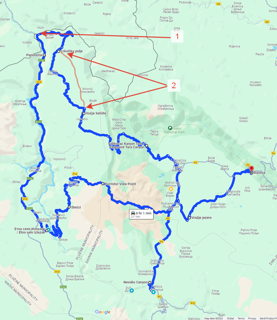
On the attached map I have left two remarks, important for those who will drive for the first time:
Google maps
GPS data
MARK 1.
The border with Bosnia is marked. The path lies along the border, and although it passes by a checkpoint on the Montenegrin side – don’t worry, you are not leaving Montenegro.
If you go clockwise – no need to wait in line at the border, bypass it. Wave your hand to the customs officer and say that you are going towards Durmitor. You will be let through, after 50 meters you will see a barrier – you can drive to the right of it if you have not been opened. Do not go left over the bridge – this is the border with Bosnia.
If you are traveling counterclockwise, when you get to the barrier, drive around to the left or press the button to be let in. Drive straight up to the border guard and tell him you are coming from the Durmitor side. He will see you. Do not wait in line for passport control.
MARK 2 (Only for GOOGLE.MAPS)
The correct paved road is marked in red. Google, unfortunately, does not know it. If you ride counterclockwise you will see a fork, go straight on the signs, and do not turn 90 degrees to the left as Google says. The whole road will be asphalt.
If you are riding clockwise, go straight to the Durmitor sign. Do not turn right.
The road that Google says is also there, but it is gravel and can be rough after rain.
From the sea to the north by the eastern route
Highlights: Risan Old Serpentine, Grahovac, Slano Lake, Kapetanov Lake, Kronovo wind farm, Savnik Serpentine, Ostrog Monastery Goole.maps GPS data Fast enough except for the road to Kapetanovo Lake. The entire road has been paved since 22. When you drive to the lake, google.maps will take you to the quarry wall for some reason. You have to go back a bit and drive up this wall on the right. To avoid going off the asphalt carefully follow my route when you return from Kapetanovo Lake. If you let google.maps to plan a route, it will lead by a gravel shortcut (MARK 1). But in general, this section is passable for heavy touring enduros with average riding skills. From Niksic you can go to Ostrog – a monastery in the rock. There will be no cellular on Kapetanov Lake (data as of 2024). The lake itself is not as magical as the road to it.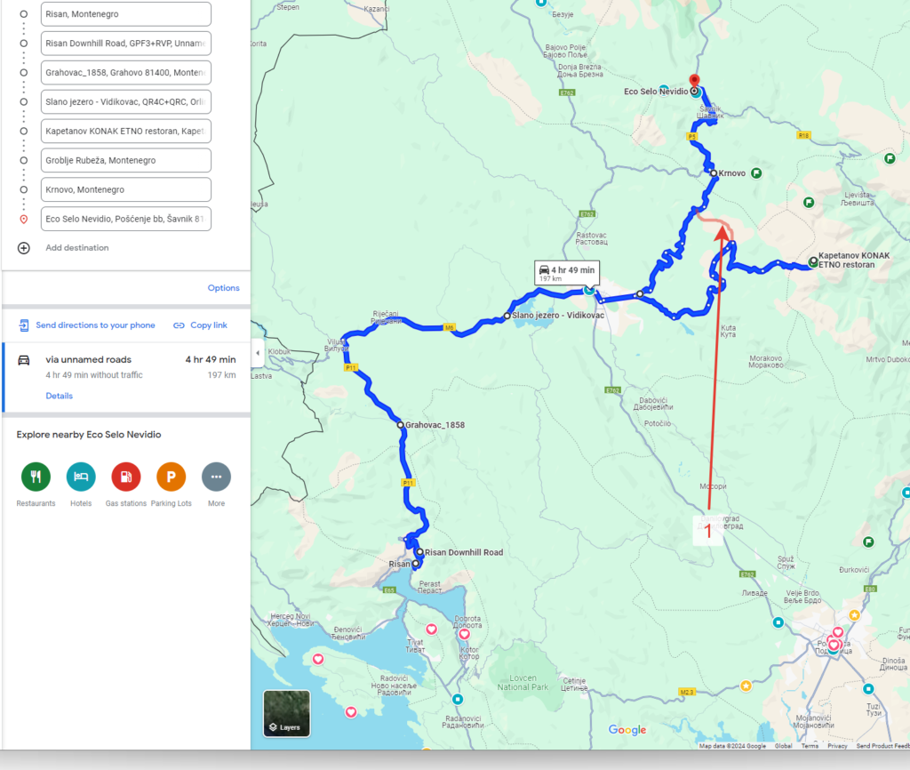
An extended circle around Korita. Grlo Sokolovo.
Highlights: Grlo Sokolovo, Bukumirsko Lake, Kolasin, Moraca Canyon, Medun, Podgorica
Google.maps
Cool route including two interesting options to get from Podgorica to Kolasin avoiding the highway. There are a couple more, but one of them is an offroad section of the TET, and the other is very slow and not that scenic.
Grlo Sokolovo Point is an equipped observation deck above the canyon overlooking the SH20 road that runs through Albania. It’s a 15-minute walk to the site, but it’s worth it. You can also ride a touring enduro with average skills.
Bukumirsko Lake the last 500 meters is also a gravel road, but not difficult and I recommend getting there. It is possible not to drive in and enjoy the views from the top, then only asphalt.
Kolaszyn is a ski resort that works and in summer you can ride the ski elevator and have a delicious meal in the national restaurant, as well as decent hotels. You can drive on the stunning off-road roads in the area or hire a jeep.
From Kolasin to Podgorica, drive back along the Moraca River canyon, a view road with the river running below.